Mapping Saskatoon: Riversdale and Chinese Laundries
Saskatoon
May 26, 2026
Categories:
By Shannon Putnam, former WDM Curatorial Intern (Western), Harris Ford, PhD Candidate History (USask) and Dr. Elizabeth Scott, Chief Curator – Director of Collections & Research
Introduction
As part of the intensive research we have been conducting on the history of the Wing Lee Lai Laundry, we have created a visual reference resource, using historical and digital maps, as well as archival aerial photography, to better understand the history of the Riversdale community in Saskatoon and its Chinese residents throughout the twentieth century. It vividly showcases the significant growth of businesses and immigration, providing historical insights that will enlighten researchers, historians and individuals interested in the history of Riversdale and Chinese immigration in Saskatoon. The various types of maps not only display the physicality of buildings, the increase in population and the shifting neighbourhoods, but also reflect the dynamic nature of the community over time. While these maps and photographs were not intended to document social history, their annotations reveal patterns of urban change and raise important questions about the lives and labour of those who inhabited these spaces.
Library and Archives Canada – Fire Insurance Plans
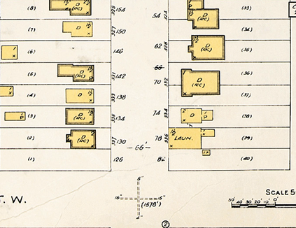
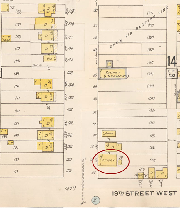
Insurance plans serve as a unique lens into Riversdale’s neighbourhood in Saskatoon and offer a close-up view of the Wing Lee Lai Laundry. While these fire insurance plans may not meticulously label each building with its corresponding business, they indicate whether a structure is residential or commercial. For instance, the structure at 336 Ave E South is identified as a “laundry,” shedding light on the commercial landscape of the time.
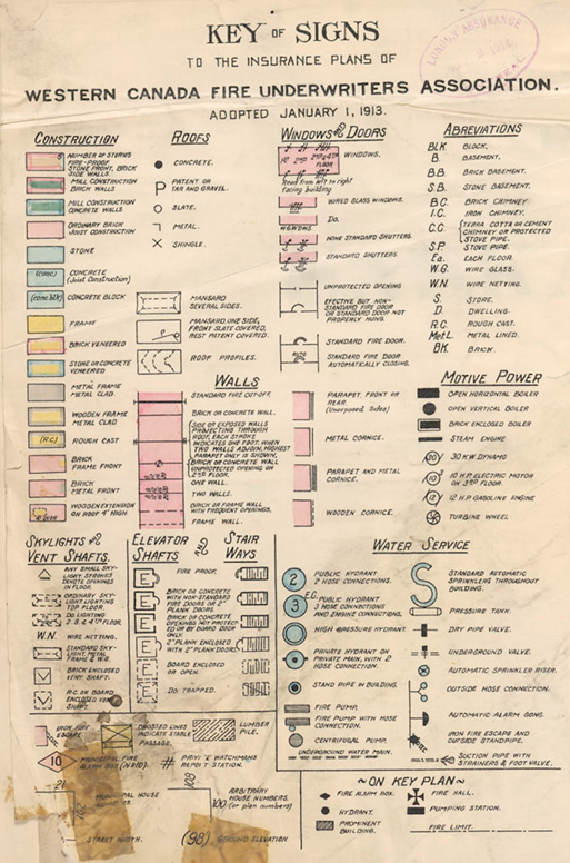
The first image serves as a key to the 1913 fire insurance plan. Consecutive plan keys are similar. However, there might be slight changes depending on the plan’s writer. It’s important to note that these plans were often revised rather than redrawn from scratch, with buildings and numbers scratched or blotted out with ink or new paper glued on top of old structures. As such, fire insurance plans may only partially represent a city’s past layout. However, they can broaden our perspective and spark new research questions.
Saskatoon City Archives – Fire Insurance Plans and Aerial Photograph
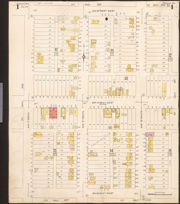
Subsequent maps illustrate the evolution of the Riversdale neighbourhood. The following two fire insurance plans are from 1950 and 1958. They are available at the City of Saskatoon Archives. It is important to note that the 1950 plan was drawn in 1923 and altered through methods described above. That said, the map creators redrew Riversdale neighbourhood entirely, and indications of changes from 1923 to 1950 are unavailable. The Western Canada Firewriters Association wholly redrew the 1958 drawing.
The 1950 fire insurance plan showcases more development on Ave E South and alterations to the 1 ½ story dwelling of Wing Lee Lai Laundry, an addition on the northeastern portion of the home and what appears to be a small shed on the adjoining lot.
What do the changes reveal to help the research process? The changes generate more research questions: Who purchased a building permit and when? What purpose does the addition serve? If many laundry employees worked and slept in the same facility – not having a separate home – is this addition a bedroom? Were the living quarters separate prior to this change? These questions open new avenues for research and deepen our understanding of the historical context of the Wing Lee Lai Laundry and others. These questions encourage us to consider the value of spatial analysis in historical research, inviting deeper analysis of these types of municipal records.
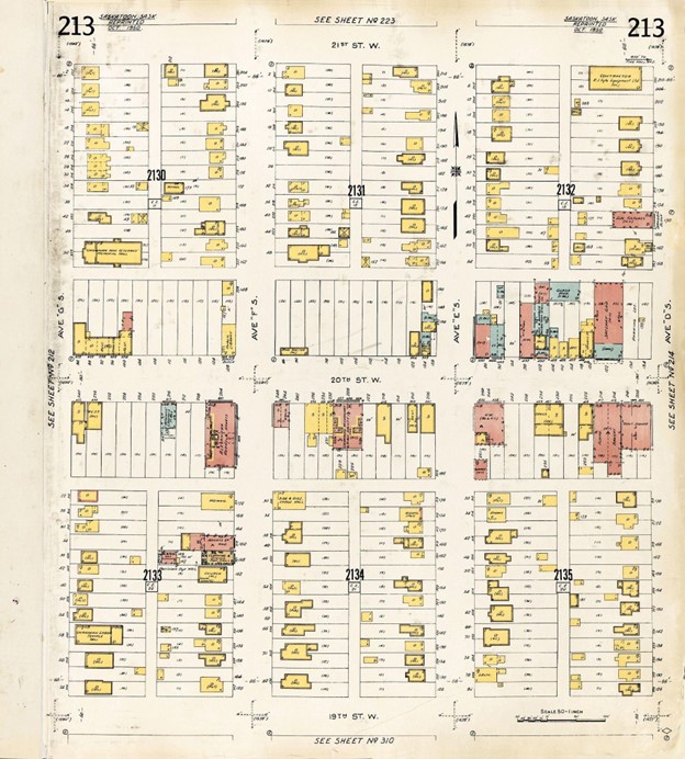
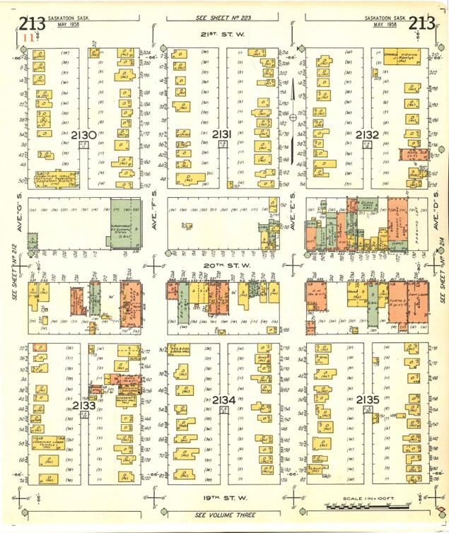
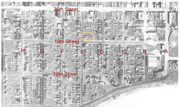
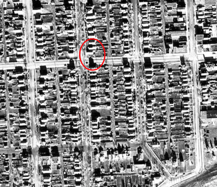
Aerial photographs provide complementary visual evidence of Riversdale’s transformation to the maps. Shannon annotated this aerial photograph to enhance our understanding of this layout. One of the first actions taken after receiving this aerial photograph was to label the diagram accordingly. The process involved cross-referencing the street locations in two ways. Firstly, she pulled up Google Maps and located the street curvature off of 18th Street to ensure we were on the right track, locating 336 Ave E South. Lastly, she pulled up the city directory for 1927 for houses labelled and built on that street. Corresponding to the Henderson Directory, the two buildings listed in the yellow circle are at 334 (the most northern building) and 336 Wing Lee Lai Laundry.
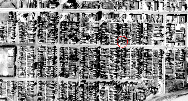
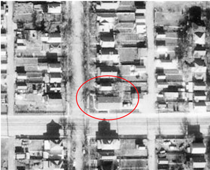
The 1977 close-up of Lot 39 and 40, Block 20, showcases the shift in landscape from prior years. The original structure of the Wing Lee Lai Laundry was demolished in 1967, the same year the laundry closed.
Mapping Using Modern Tools
Harris Ford, a PhD candidate at the University of Saskatchewan, generously shared the following three images. He created these maps while researching Riversdale’s neighbourhood during his undergraduate degree. His project trajectory focused more on Chinese-owned restaurants rather than laundries. His insights and contributions have been invaluable to this research.
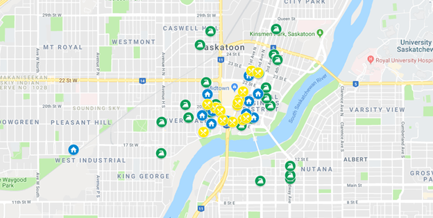
Chinese Residents in Saskatoon in 1921 Map: This map is an excellent resource for understanding the Chinese community’s presence there during this period. It visually represents the distribution of Chinese residents and highlights their contributions to the city’s cultural and economic landscape.
Legend
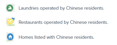
This map showcases the location of all laundries, restaurants and residences of Chinese settlers in Saskatoon in 1921. While there were separate homes, many residences were on the second floor or at the same address of businesses. The concentration of the current downtown area is primarily due to Saskatoon’s size and geographic scope in 1921. Information for this map was gathered from the 1921 census.
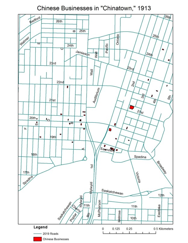
This 1913 map builds off the fire insurance maps to show Chinese businesses located in “Chinatown.” The concentration of buildings is around 19th Street East with various other Chinese-operated business also on 20th Street West as well as on other streets in the Riversdale region. Information for this map was gathered from the Henderson Directory of 1913 and fire insurance maps.
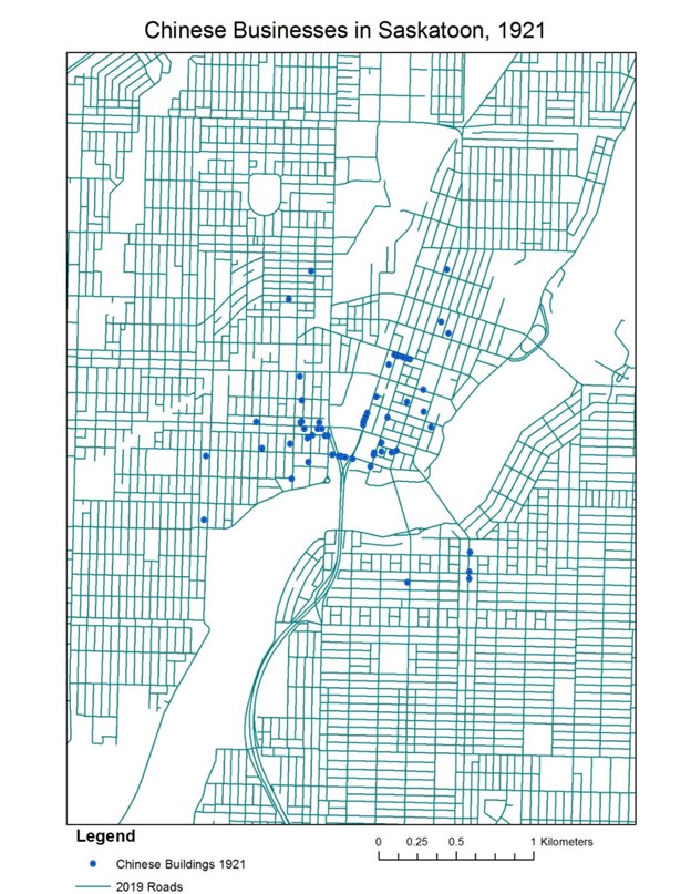
This map from 1921 is a sample of a common trend in Saskatoon’s Chinatown. Often Chinatowns are met with the expectation of cramped quarters, geographic limitations and Chinese-only spaces. Instead, this map shows the urban sprawl of Saskatoon’s Chinese community – something Saskatoon’s Chinese population exhibited throughout the decades. There is a hub around 19th Street East and 20th Street West. However, there were restaurants and laundries along Broadway, businesses well north of 25th Street W, and east past Avenue H. A flight school for the Chinese nationalist army existed from 1919-22 on the outskirts of the city, and businesses were also located in the still unincorporated region of Sutherland. Furthermore, these spaces were not exclusive to Chinese settlers. Even where Chinese businesses are common there were a myriad of non-Chinese settler shops and shoppers interwoven with the cityscape.
The maps and visuals presented here illuminate a complicated picture of the Chinese experience which goes beyond common perceptions and showcases the constant changes inherent to a growing city. Through our study of historical maps and photographs, we have gained a richer understanding of how Chinese communities contributed to Saskatoon’s development. Next time you take a walk through Riversdale, or visit the Wing Lee Lai Laundry exhibit on Boomtown Street at the WDM Saskatoon, try and layer in the maps and the aerials to enhance your historical perspective on this important neighbourhood in Saskatoon’s history.
